The wilds of County Mayo are spectacular. Along the rugged west coast the skyline is marked by the Partry and Nephin Beag ranges. On Achill Island, the northern slopes of Croaghaun mountain plummet from 600 m OD to the sea below, while on it’s southern side it shelters one of the most beautiful beaches in Ireland, Keem. To the southeast of here is Clew Bay with its plethora of low drumlin islands, while inland the landscape is dotted with rivers, lakes, bogland and the occasional turlough.
Lough Mask is located to the south of Co. Mayo. Along the lakes western shore is the village of Tuar Mhic Éadaigh, and if you ever get the chance, I would recommend the trip from here to Westport across the hilly and barren emptiness of Aughagower. The landscape comprises blanket peat that is unproductive, there are few homes though there are the crumbling ruins of many vernacular houses long deserted. Wild and ragged mountain sheep roam the narrow roads.
It is just south of this area that you’ll find the little hamlet of Finny. On high land, it affords spectacular views of a narrow part of Lough Mask. Almost directly across from Dead Island on the lake, and along the R300 road, is Old Finny National School. The building is disused now, and being so off the beaten track, it probably has very few inquisitive visitors.
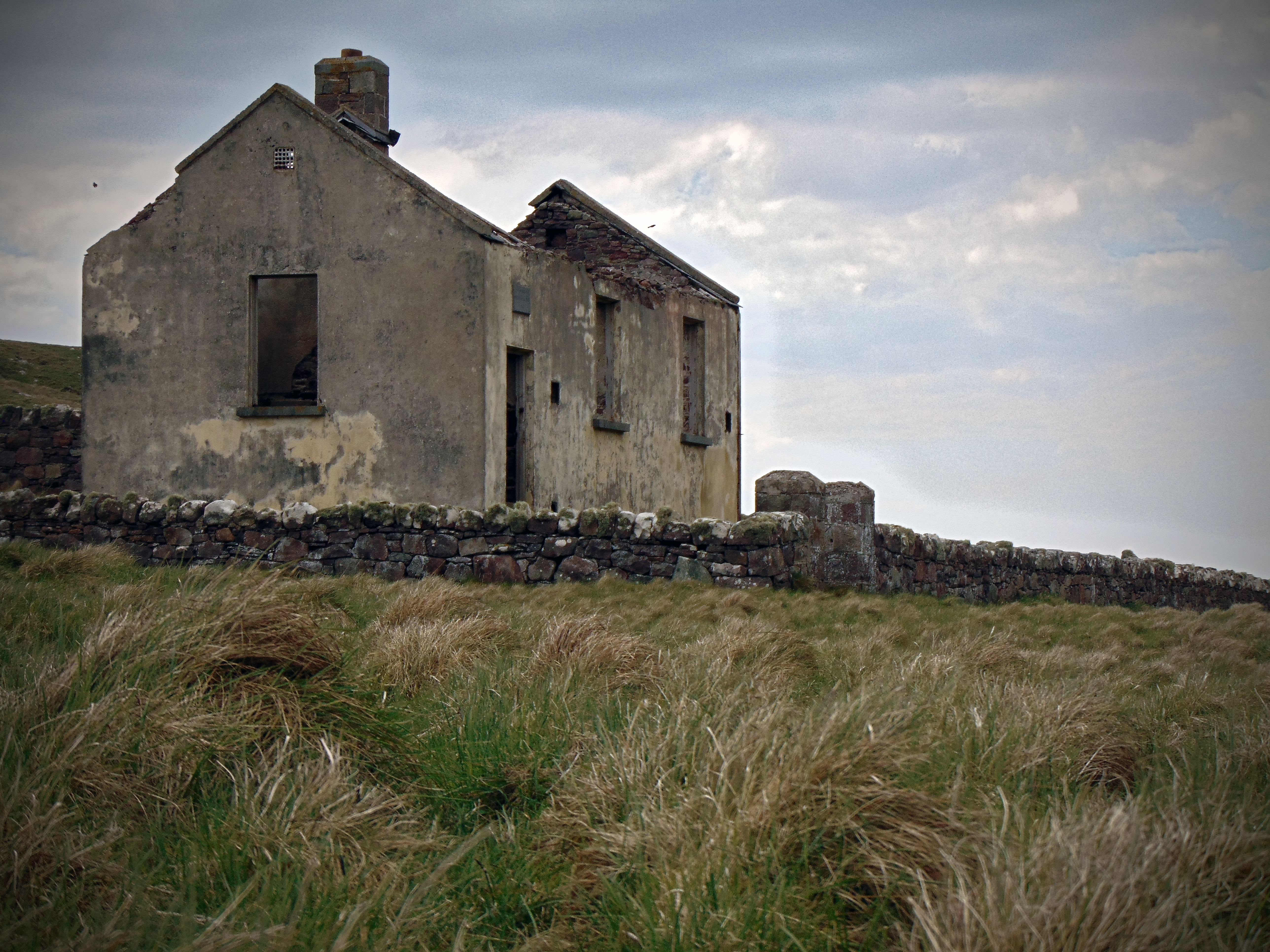
Achill Beg National School, Achill Beg Island, Co. Mayo
(Dated 1903)
NGR: 071712, 292437
If you were to include just about every rocky outcrop of notable size, then you could count at least five-hundred-or-so off-shore islands off the coast of Ireland. However, only a handful of these islands have maintained a population through history, and even fewer-still have retained permanent residents into the present day. Through the early and high medieval period many of the smaller islands off the west coast attracted monastic settlers. Off the west coast, monastic settlements can be found on Skellig Michael, St. Macdara’s Island, Scattery Island and Inishmurray to name just a few, with the early monks being drawn to the isolation offered by these punishing out-posts.
However, our period of interest is the 19th and 20th century, and the experiences of those who lived and were educated on these islands at that time. Examining the early mapping sources like the First Edition 6 Inch map (1834-1842), and First Edition 25 Inch map (1890-1911), it can be seen that up until the mid 20th century, there were some forty national schools located on islands off the coast of Ireland. Life on many of these islands could be harsh at the best of times, and by the 1950s, settlers on many of the smaller islands were encouraged to leave and settle on the mainland. The evacuation of the off-shore islands left many of the smaller islands desolate and empty, and consequently, the majority of the forty national schools once located on them were closed.
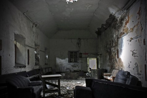
For the past couple of months I’ve been slowly making my way out to many of these island school houses. Some have unfortunately been completely destroyed by the elements such as the school house once located on the eastern shore of Scattery Island, Co. Clare. Others have been restored as holiday homes like the example on Dursey Island, Co. Cork. And some, such as the example featured here from Achill Beg, have been sitting vacant and abandoned since the island was evacuated in the mid-20th century.
Gola Island National School, Gola Island, Co. Donegal
(Dated (1846), 1880-1900)
NGR: 177221, 426202
North-west Donegal is possibly about as remote as you can get on the island of Ireland, and the islands off the Donegal coast are as isolated a spot as you will find anywhere in the county. Many do not have permanent populations, and if you’re ever need to get away from it all, this is the place for you.
Gola (in Irish Gabhla or Oileán Ghabhla) is a small island off the coast of Gweedore. The island measures 424 statute acres, with mildly hilly terrain. It is a haven for artists, birdwatchers, photographers and walkers, and the cliff s on the north side of the island attract many rock climbers. Near the island’s lake, bird life abounds; cormorants, razorbills and guillemots, as well as gannets and kittiwakes, can be admired. Although many Irish people may not realise it, they may be familiar with Gola Island through song: it is the birthplace of renowned Irish writer Seán ’ac Fhionnlaoich, and the island has also been immortalised in the traditional children’s song Báidín Fhéilimí (‘Féilimí’s Little Boat’).
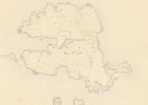
The First Edition Ordnance Survey 6 Inch Map Showing Gola Island in the late 1830s
For centuries, a couple of hundred people eked out a living on Gola from fishing and subsistence farming. By the 1950s, however, the island could no longer compete with the economic opportunities off ered by the mainland. Gradually, Gola’s families stripped their houses, boarded their boats and sailed away to the mainland. Th e closure of the island’s national school in 1966 marked the beginning of the end, according to Síle Uí Ghallchóir who was one of the last pupils at the school.
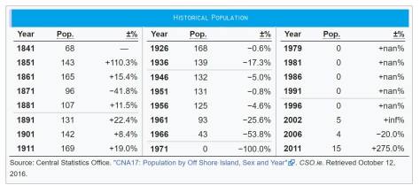
Since the 1960s onward the trend on most of the off-shore islands has been a decreasing population. In fact, during the 1950s and 1960s, many of the smaller islands were forcefully evacuated by the Irish Government as continuous bad weather meant that islanders were unable to travel to the mainland for several consecutive months. The most recent census taken during 2016 showed 15 permanent residents on Gola, although the return of permanent settlement to the island is a recent phenomenon, with the island being largely unpopulated since the late 1960s.
In 2005 the island was connected to mains electricity for the first time, and from being totally deserted over 30 years ago Gola now has electricity and water and the future looks far more positive. However, the population remains small and somewhat seasonal.
Gola Island National School, Co Donegal, with Mount Errigal in the backgroud
Located on the shore, the old schoolhouse on Gola is in a most precarious position, with coastal erosion threatening to erase the structure from the landscape. Stormy weather in recent years means the sea now comes right up to the door at high tide. It is weather-beaten, the roof has collapsed and in all likelihood it will be completely washed away in the coming years. (Such was the fate of the old schoolhouse on Scattery Island off the coast of County Clare). Continue reading Gola Island National School, Gola Island, Co. Donegal→
The village of Bunbeg is a relative stones-throw from Gweedore and Bloody Foreland in West Donegal. Just outside the little village in the townland of Knockastolar, and perched above the road from Bunbeg to Dungloe at a Y-junction, is a schoolhouse lying empty, and painted in the green and yellow of Donegal. Its date plaque was missing, although its form suggests it is a late nineteenth-century schoolhouse with a later extension perhaps. The original section of the building is identical to the old schoolhouse on Whiddy Island off Bantry Bay in County Cork (dated 1887), with an entrance porch to the side.
Knockastolar National School, Co. Donegal (1880 -1900)Knockastolar National School, Co. Donegal (1880 -1900)
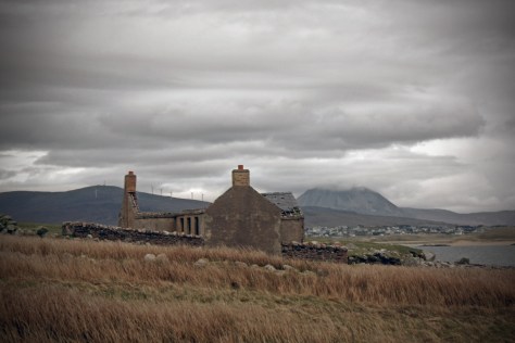
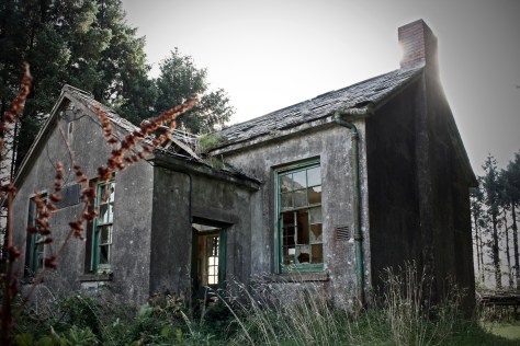
Carrigagulla National School, Carrigagulla townland, Co. Cork/Scoil Carraig an Ghiolla, Co. Chorcaí
(dated 1934)
NGR: 138313, 084161
The parish of Macroom in Co. Cork is situated about halfway between Cork city and Killarney on the modern N22 roadway. Each day, significant volumes of traffic pass through the town of Macroom, with drivers unaware perhaps, of the locality’s rich and diverse cultural landscape. Crossing the River Sullane, the charred and imposing ruins of Macroom Castle overlook the the river below. Within the town, Macroom Market House (built c.1820) is a focus for remembrance, with many memorials and commemorative plaques including one to commemorate the 300th anniversary of the granting of market rights to the town of Macroom by Queen Anne on 30th September 1713.
There are few counties to rival Cork for the scale of its post-medieval and industrial heritage. But exploring the area around the parish in search of a disused school house in the townland of Carrigagulla, it was an obscure and understated industrial project from the mid-18th century that attracted my attention.
The townland of Carrigagulla is surrounded by the amphitheatre of the Boggeragh Mountain foothills. Here in the townland, adjacent to the Millstreet-Rylane roadside, are the ruins of Carrigagulla National School. But the Millstreet-Rylane roadway has its own story to tell about life in this rural area through the 18th and 19th centuries.
The Cork-Tralee turnpike road, better known as the ‘Butter Road’ was completed in 1748.Its construction was undertaken by John Murphy of Castleisland, who constructed the 56 miles of road including nine large bridges, 15 small bridges, toll house and turnpike gates. It was a requirement of the construction that the road be 30ft (9.14m) in width with drainage ditches and a 15ft wide (4.57m) gravelled surface. It became the main route by which farmers from Kerry and western Cork took their butter to the Cork Butter Exchange in the city (Rynne 2006, 317).
The turnpike system had been introduced into Ireland in 1729. Intended to provide good inter-county roads, turnpike roads were built and maintained by turnpike trusts which were generally run by local landowners. The turnpike act empowered named trustees to erect gates and toll houses on the roads and provided a loan for their construction. The toll monies, collected from all but pedestrians and local farmers who used the roads daily, were intended to maintain the road and repay the loan (ibid., 315).
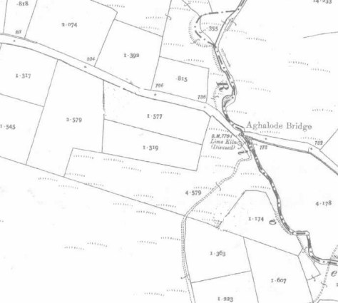
The Cork-Tralee turnpike road is today but a back-road, with the majority of traffic passing along the N22 between Cork and Kerry. The area is quite, the hills are largely forested, or bare and boggy, and the once bustling highway is often empty of traffic. However, at Aghalode Bridge, and adjacent to the Aghalode River, there is an old school house that is perhaps a reminder of a more thriving time in this rural spot. On the west side of the Butter Road you’ll find the remains of Carrigagulla National School/Scoil Carraig an Ghiolla.
Carrigagulla National School, Co. Cork – 1934
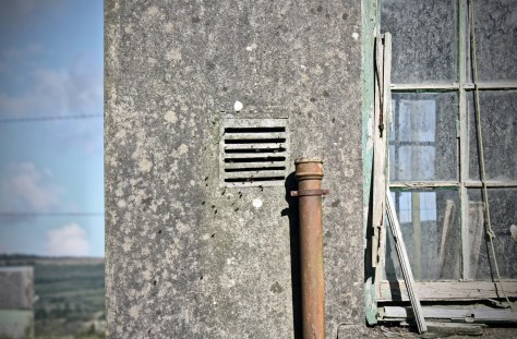
Constructed in 1934 it is a simple, detached, two-bay, single-storey national school on a T-shaped plan, having a gabled projection to the centre of the east elevation.Though still roofed, it is in a poor state of repair. From the outside the building is certainly institutional in appearance; the rough grey rendering is not inviting, the surrounding schoolyard is overgrown, and the foreboding hum of a wasp’s nest deters visitors. The dull-green, pealing paint on the window frames and rainwater goods only seem to emphasise the buildings predicament. A squadron of wasps emerge from the brickwork chimney stacks and air vents as I get a little closer.
The picturesque town of Moville lies on the western banks of Lough Foyle in County Donegal where the Bredagh River flows into the sea. The locality was the adopted home of the dramatist Brian Friel, and it still attracts many visitors who make the long journey north to the Inishowen Peninsula and Ireland’s most northerly point on nearby Malin Head.
At the turn of the nineteenth century there were just 50 people living in the town of Moville, but the town would rapidly develop over the following decades. During the second half of the nineteenth century, Moville was a significant point of embarkation for many travellers, especially emigrants to Canada and the USA. Steamships from the Anchor and McCorkell Lines and others en route from Glasgow to New York, Philadelphia, Quebec and New Brunswick regularly dropped anchor in the deep waters off Moville to pick up additional passengers
The new trade brought wealth and development to the town, and a growth in population. Naturally, the growing population would need education, and there were a number of national schools constructed, not just in the town, but in the hinterland also. The schoolhouse featured here is one such building. Scoil Bhride Culaidh is located near Cooly Cross, a rural spot just 3km north-west of Moville.
The building itself dates to 1931, but examining the First Edition 6-inch and 25-inch Ordnance survey maps, you can see that this school house replaced an earlier school named ‘Tiyrone School’ just a few hundred metres to the east. This earlier school house, which dates to at least the 1840s, was unusually located away from the roadside, enclosed in the corner of a field. Two ‘right-of-ways’ led to the school through the surrounding farmland. Perhaps someone out there has an explanation for this school’s inconvenient setting? Was it perhaps built on land donated by a local landowner? Today, an area of rough ground marks the location of the original school building.
The parish of Dysart (occasionally spelled ‘Dyzart’) is located about 3 kms from Dunleer in Co. Louth, on the coast road from Drogheda to Dundalk. In 1837 the village was visited by the travelling antiquarian Samuel Lewis who reported 699 inhabitants living in the parish at the time. He noted that the land was of superior quality and well cultivated: about two-thirds in tillage, and about 50 acres of bog. In the village of Grange Bellew, there was a mill for grinding oatmeal, and another for dressing flax. Among the most notable buildings in the parish was the old castle of John Bellew in Barmeath (one of the lords of the English pale). At the time of Lewis’ visit it was the residence of Sir Patrick Bellew, and stood ‘in a richly wooded demesne, commanding extensive views of the surrounding countryside’.
In the village of Dysart, Lewis remarked on the handsome chapel there, the site for which was presented by Sir Patrick, who also contributed towards its erection. A quick look at the Ordnance Survey 6-inch sheet which dates to just a few years after Lewis’ visit, shows there were few buildings in Dysart during the 1830s-1840s, bar the aforementioned chapel, and a national school.
First Edition Ordnance Survey 6 inch sheet showing Dysart, Co. Louth.
Lewis recorded that the school of about 160 children was aided by Sir Patrick, who also contributed largely towards the erection of the school-house. Though now derelict, this building still stands today. Continue reading Dyzart National School, Dysart townland, Co. Louth→
Munterneese National School, Munterneese townland, Co. Donegal
(Dated 1938)
NGR:183512, 375634
Located in the south of Co. Donegal, and on the northern shore of Donegal Bay, the village of Inver is sometimes referred to as the hidden jewel of the northwest. In recent years, the ‘Wild Atlantic Way’ coastal driving route has brought an increase in tourism to the area, with the parish being situated on the bay of Inver. Nonetheless it remains a quiet spot; rural in character with hilly and rough grazing land that is occasionally lashed by Atlantic winds and rain.
Although now quiet, the area was once home to an important whaling post during the 18th and 19th century, and a large whaling station and fleet was based in the Port of Inver, 2 km from the modern Inver Village.
Thomas and Andrew Nesbitt set up the whaling business in Donegal Bay in 1759. Thomas was the inventor of the gun-harpoon, which was witnessed by Arthur Young during his tour of Ireland 1776-1779, as he states: “From many experiments he brought the operation to such perfection that, for some years he never missed a whale, nor failed of holding her by the harpoon”.The ruins of the old whaling station still remain in the port but have eroded and deteriorated to rubble.
During the 19th century the area was busy enough to require a railway, and Inver railway station opened on 18 August 1893. However the final train passed through the station on 1 January 1960. It has been closed since.
Just a few kilometres east of Inver Village and situated to the south of the old railway tracks, are the townlands of Munterneese and Drumcoe. The townlands are sparsely populated today, though a quick glance at the historic mapping for the area shows that in the time since the publication of the First Edition Ordnance Survey 6 inch map series in the 1840s, there have been no less than four school houses constructed in this small area. Only two if these buildings remain today (both disused), and this blog post looks at the last of these to be constructed; a detached six-bay single-storey national school, dated 1938. Continue reading Munterneese National School, Munterneese townland, Co. Donegal→
The island of Ireland is small but diverse. From the southwesternmost point at Mizen Head in Co. Cork, you need only travel about 550 km to reach the northerly tip of the country at Malin Head in Co. Donegal. But along that journey, you will witness a variety of landscapes, both physical and cultural – each different from the other in striking, or sometimes subtle ways. From productive mixed farmlands for both tillage and stock, to the mire of endless bog, the physical landscape has been shaped and manipulated, initially by geological process, and subsequently by the the people who have lived in it. Particularly in rural Ireland, the physical and cultural landscapes are entwined and form a narrative that is often not immediately clear, that requires an insight into, and interpretation of what shapes the lived experience of the world around you. In short, the landscape and what it contains tells the history of it’s inhabitants.
This blog post features the first abandoned school house from Co. Donegal (the northernmost county in Ireland) that I’ve visited, and it’s difficult to communicate the significance of the school without first placing this building in context.
Lettermore National School, Co. Donegal (1909)
The slogan ‘Up here it’s different’ has been used to promote tourism in, and attract tourists to the Donegal region in recent years. But what makes this area different? In terms of geography, Donegal is pretty similar to West Cork, Kerry and Connemara; a rugged western coastline shaped by the Caledonian Orogeny, and battered by the Atlantic Ocean, mountainous lands of blanket bog to the west, better, more productive lands to the east.
But Donegal different to these other places. Depending on your perspective, the circumstances of history have not done Donegal any favours other than to perhaps help preserve it’s striking landscape. The Partition of Ireland in the early 1920s had a massive direct impact on the county. Partition cut the county off, economically and administratively, from Derry, which had acted for centuries as it’s main port, transport hub and financial centre. But even before this, Donegal was one of the worst affected parts of Ulster during the Great Famine of the late 1840s. Vast swathes of the county were devastated by this catastrophe, many areas becoming permanently depopulated. Vast numbers of people emigrated at this time. Particularly in West Donegal, there was a spiral of decline from the 1900s onward, and what was once seasonal migration from the islands and highlands was replaced by more permanent migration to cities in Britain such as Glasgow.
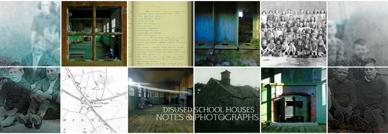
This week (August 20th – 28th) marks National Heritage Week in Ireland. It is a multifaceted event coordinated by The Heritage Council that aims to aid awareness and education about our heritage, and thereby encouraging its conservation and preservation. As part of Heritage Week 2016 there are daily posts to the Disused School Houses Blog, and this is the seventh post in the series. This post takes a look at the one-roomed school house in rural Ireland, and it’s significance as a symbol of the development of a more progressive education system for all.
A few miles north of Dunmanway in West Cork, is the little rural hamlet of Cool Mountain. Through the 1970s, this area was settled by a commune of mostly English folk, who felt Poll Tax and Thatcherism wasn’t for them, and so they made the mountain sides their home. In summer, this is a particularly lush and green place; wooded and mountainous, isolated and peaceful. The land is rough but resourceful, and it’s easy to see what attracted the settlers to area in the 1970s. The landscape of Cool Mountain seems to have retained an authentic rural feel; the roads are poor, the houses sparse, and there is a sense of timelessness about the place.
Here, located just off a small local road, and partially hidden by trees, is the disused Cool Mountain National School; a diminutive one-roomed corregated iron structure that is among the more unusual school houses I’ve seen to date.
Cool Mountain National School, Co. Cork
Built sometime in the 1950s, it replaced an earlier local school house, though the galvanise building only contined to operate as a school until 1969 before closing. It is a quintessential yet unconventional one-roomed school; unconventional in it’s design and the materials used in it’s construction, though quintessential in it’s former role as the hub of education in a rural location. Continue reading At the heart of it all; the one-roomed school house in rural Ireland (Heritage Week 2016 Series)→