Tag Archives: Abandoned Schools

The School House in Ireland: Architecture and Meaning – Part 1

The School House in Ireland: Architecture and Meaning

Henry Glassie is a professor of folklore at Indiana University in the United States. He has published extensively on the topic of material culture, and in the 2000 he published a book that was simply titled Vernacular Architecture. Glassie’s publication drew on his three decades of observations of vernacular architecture from around the world, and showed that common buildings, and the meanings and associations attached to them, contributed to a more democratic telling of history. Glassie viewed buildings like poems and rituals, in that they realise culture and reflect in a material way, the thoughts, beliefs and experiences of the people that design, build and use them. Of course, this is true about all architecture, not just the vernacular traditions. But what do we mean when we talk about vernacular architecture, and are school houses vernacular structures, or imposing institutional buildings?

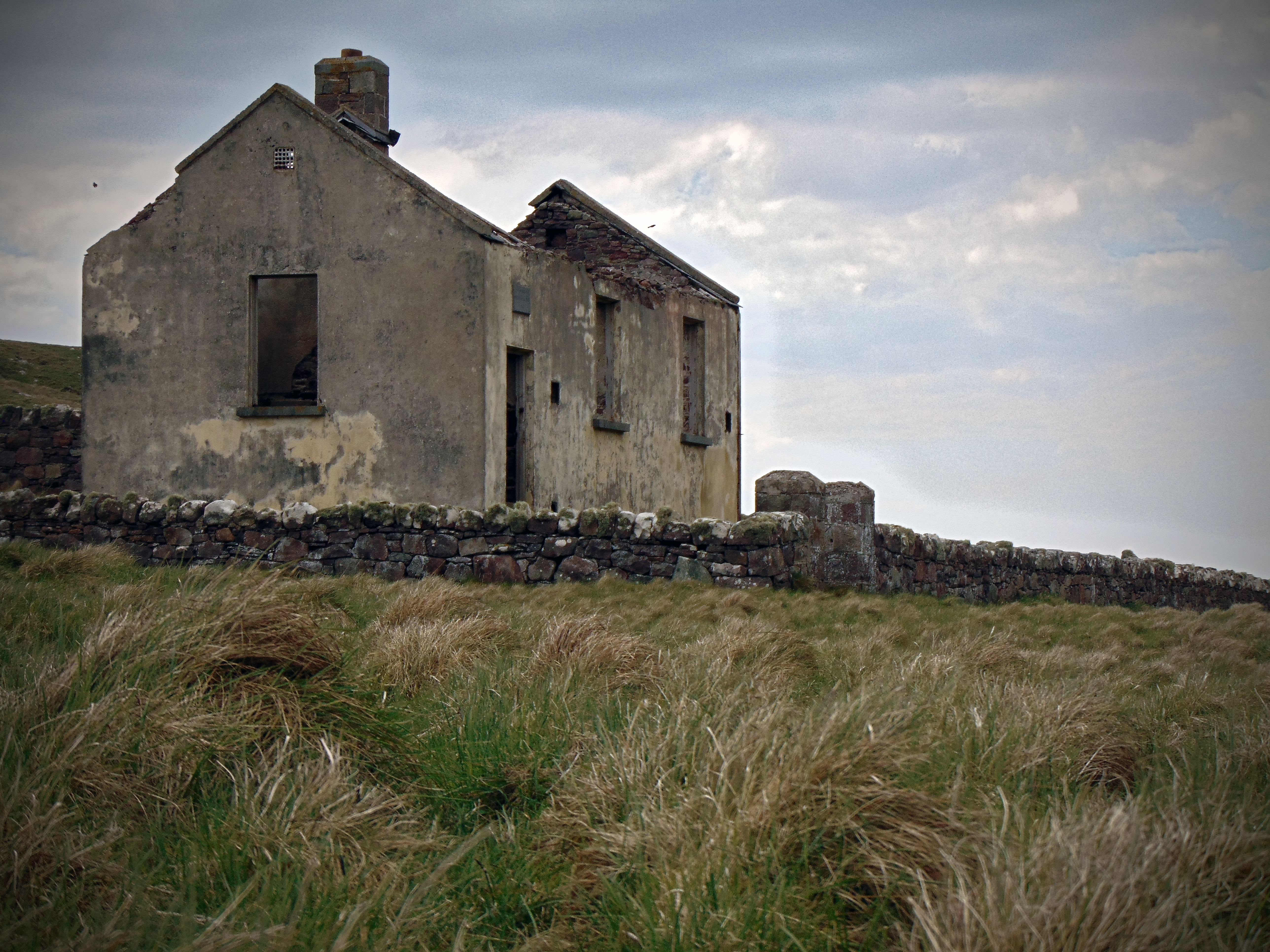
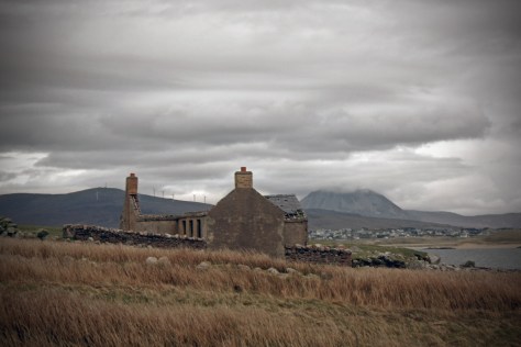
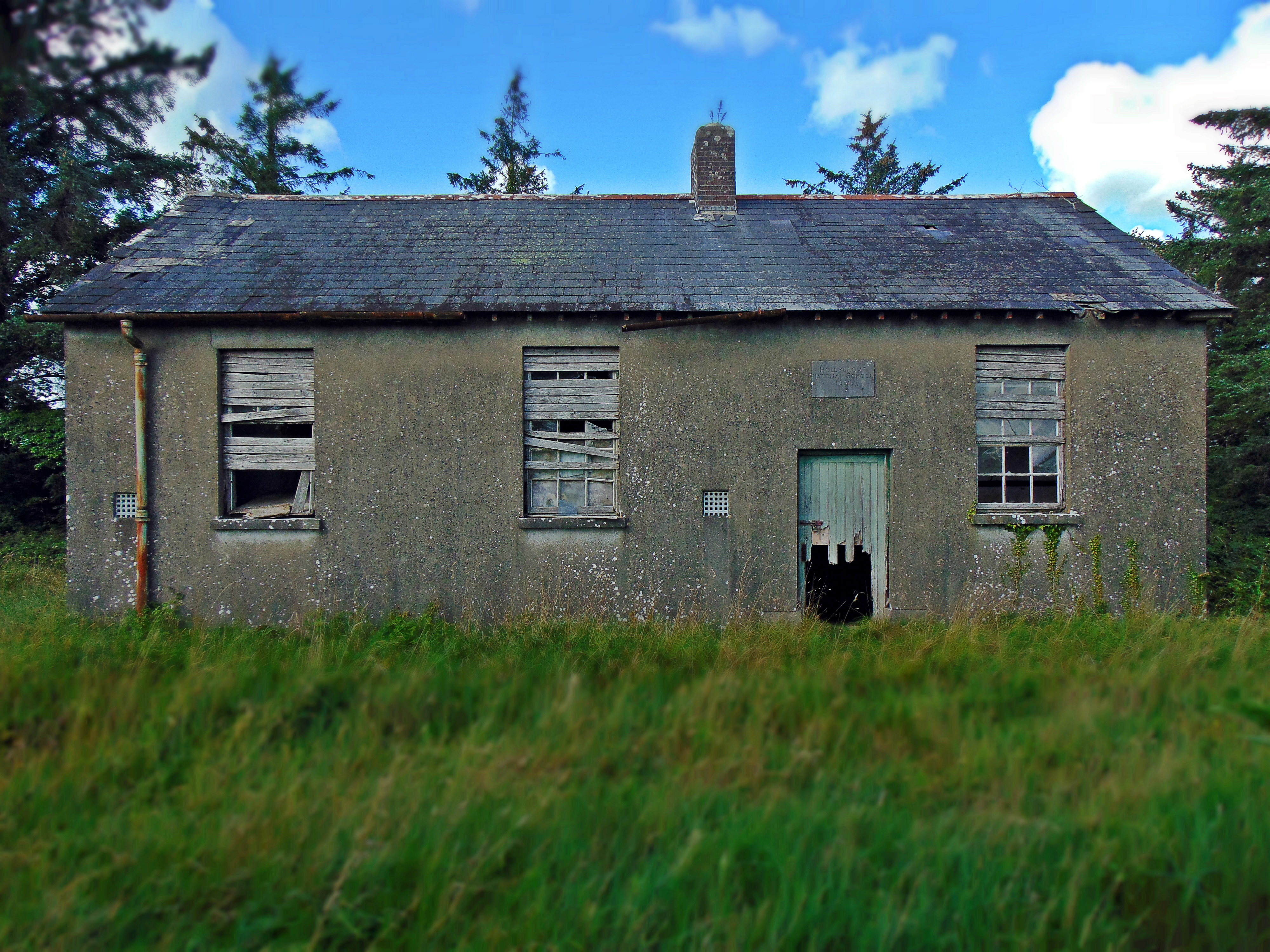
Vernacular architecture exists everywhere there are human populations around the world. It can’t be defined as a particular architectural style that you might recognise like Baroque or Neo-Classical, but rather a building paradigm where the arrangement of the structure is the simplest form of addressing human needs. It is a pure reaction to an individual person’s or society’s building needs, and has allowed everyday people, even before the architect, to construct shelter according to their circumstance. Some are the exotic products of indigenous people in places unknown to us. But others are familiar, maybe too familiar, and so are overlooked and unappreciated. This is the case with many of the school houses featured here.

Hollygrove National School, Hollygrove townland, Co. Galway (dated 1899). This plain two-room school house is a fine example of one of the most simplistic ‘factory school’ designs supplied by the OPW at the turn of the 20th century. Despite their pivotal role in education in rural Ireland at the time, many of these buildings are not recorded in the National Inventory of Architectural Heritage

Vernacular buildings are composed of local materials. The meanings that lie in the selection of materials are social and economic as well as environmental, and the buildings very much reflect the local area and its people. They can tell us a lot about the people that constructed them. As Glassie states; ‘culture gathers into an inner resource of association and gathers order aesthetically, by which he means that the landscape and how people view and experience the world is reflected in what they build and create. With the act of physical alteration that calls time into space implying a past and a future, and with the walls that divide space, at once including and excluding, architecture has happened’ (ibid.). Architecture gives physical form to names and claims, to memories and hopes. As a conceptual activity, architecture is a matter of forming ideas into plans, plans into things that other people can see. Architecture shapes relations between people. It is a kind of a communication (ibid.). Continue reading The School House in Ireland: Architecture and Meaning – Part 1

School Days Over: Spaces, Places and Memory

School days over: spaces, places and memory

The autumnal evening sun hangs low in the sky, and the few clouds that have lingered as twilight beckons are tainted red and orange around their fringes by the setting sun. From the forested hills of the Slieve Aughty Mountains in south Co. Galway, I can see across into Co. Clare, with the stoney plateau of the Burren silhouetted blue by the bright, dropping sunlight. I’ve spent the day touring around South Galway indulging in a recent pastime of mine; looking for what I consider to be a derelict beauty. Beside where I’m standing on the low hillside, and hidden in the dense forestry plantation of the Slieve Aughtys, is the now-disused, one-roomed Reyrawer National School; dilapidated and empty, haunting and isolated. I’m here to photograph the school, and to get a sense of the local environment, both in its present state and in the past.

Looking out of the classroom window of Reyrawer National School in the Slieve Aughty Mountains

The landscape around here has changed significantly over the past 50 years. The now forested hill-sides are dotted with the ruins of former farmsteads. The former pasture and rough grazing lands have been sown with coniferous plantations, and the ubiquitous and imposing wind-turbines highlight the movement away from agrarian living in this area, as an alternative and profitable use is sought for this now people-less landscape. In the Aughtys, the result is an empty space, a desolate place where few people live. An unintended but welcome consequence of this depopulation is the creation of a welcome retreat from the ribbon development popular across much of the Irish landscape – though the man-made forests bear a hunting watermark of former settlement, with field boundaries, bóithríns, houses, farms, and infrastructure such as disused schools, hidden throughout the forests. When Reyrawer National School was in use, this was a lived-in landscape which supported a scattered, largely agrarian population. With the movement away from this lifestyle, the landscape was emptied and the school was no longer needed. The plaque on the eastern gable of the building dates the construction of the school to 1891. It closed in the late 1950s.

The landscape of the Great Blasket Island with the old national school barely recognisable in the centre

From travelling the countryside to photograph these old schools, I can tell you that there is a greater proliferation of abandoned schools in more rural and depopulated areas, with a near absence of them in urban centres. To begin explaining this let’s start with the establishment of the National Schools Act in 1831. Shortly after the establishment of the National Schools Act, Ireland’s population began to decline dramatically, initially triggered by the Great Famine of the 1840s. Between 1840 and 1960, the population of the 26 counties of what would become the Republic of Ireland fell from 6.5 million to 2.8 million. However, this decline was driven by mass emigration, and birth rates in Ireland during this time were amongst the highest in Europe. Because of this fact, despite a dramatically falling population, the need to educate significant numbers of children of school-going age remained. New school buildings continued to be required and used. There were particular spikes in new-builds after the National Schools Act in 1831, and again 1926 with the School Attendance Act which meant parents were legally obliged to send their children to school for the years between their 6th and 14th birthdays. Continue reading School Days Over: Spaces, Places and Memory

Bunglash (Bun Glaise) National School, Bunglash South townland, Co. Kerry

Bunglash (Bun Glaise) National School, Bunglash South townland, Co. Kerry

(dated: c.1873)

NGR: 69192, 87189

On 12 September 1893 the Great Southern and Western Railway opened a branch line off the existing Tralee–Mallow line, connecting the village of Farranfore with Valentia Harbour on the southern shore of Dingle Bay. At that time it was the most westerly railway line in Europe and passed through some of Ireland’s most spectacular scenery as it climbed through Kerry’s mountainous countryside. It served as the main transport system for the Iveragh Peninsula for 75 years, with the last train departing Killorglin on 30 January 1960.

So, for 67-odd years, a steam-powered locomotive chugged daily along the Farranfore–Valentia Harbour line, passing just north of the glacial lake Lough Carragh, and stopping at Glenbeigh Station. This station was at the foot of Seefin Mountain, and the surrounding landscape at the turn of the twentieth century was beautiful, wild and remote. There were few distractions intruding from the outside world, and the coming and going of the steam train punctuated the day. In the surrounding hills and mountains, schools did not have clocks, and the whistle of train in the quiet landscape as it passed over Curraheen level crossing at 10.15 a.m. let the local schoolchildren know that it was am sos (‘break time’).

Bunglash National School, Co. Kerry - 1873
Bunglash National School, Co. Kerry – 1873

Continue reading Bunglash (Bun Glaise) National School, Bunglash South townland, Co. Kerry

Milleen National School, Milleenduff Townland, Séipéal na Carraige (Rockchapel), Co. Cork


Milleen National School, Milleenduff Townland, Séipéal na Carraige (Rockchapel), Co. Cork

(Dated 1914)
NGR:  122001, 119413

The village of Roundwood in Co. Wicklow claim that at 238 m OD, their’s is the highest village in Ireland. However in recent years, the village of Meelin in Co. Cork has erected a braggadocious signpost at the edge of their humble home stating ‘Welcome to Meelin – Ireland’s Highest Village’. The  brazen folk of this tiny north-Cork hamlet claim that their little settlement, located just south of the Mullaghareirk Mountains, is 15 m higher than their Wicklow rivals. If you investigate the issue online, you might find various reasons why one village believes the other’s claim to the title of the most elevated settlement is illegitimate. In all honesty, the argument could probably be settled in minutes by pulling out an Ordnance Survey Map… but what’s the fun in that?

The plucky village of Meelin is located in northwest Cork. It is one of a handful of small villages located north of Newmarket near the Cork-Kerry-Limerick border. It is unlikely that your travels would ever take you through this area; much of the land close to the village is planted with coniferous trees, mainly of lodgepole pine and Sitka spruce. The area is sparsely populated though the woodlands are filled with ruined cottages and farmsteads which remind you that there was a time when the lands here were farmed rather than planted with commercial forests.

Old Milleen National School - 1914 (Cassini Map Extract c.1940)
Old Milleen National School – 1914 (Cassini Map extract c.1940)

It is here amongst the plantations just north of the village of Rockchapel that you will find the now disused Old Milleen National School in the townland of Milleenduff. The building is hidden from view by mature evergreens, with the Caher River flowing just to the south. On a bright day, sunlight flashes through moving branches of the surrounding woodlands onto the south-facing gabled entrance with it’s centrally placed name and date plaque. The planted woodlands have largely consumed the surrounding vernacular farming landscape that existed to the east here when the school was in use.

Old Milleen National School - 1914
Old Milleen National School – 1914
Old Milleen National School - 1914
Old Milleen National School – 1914

Continue reading Milleen National School, Milleenduff Townland, Séipéal na Carraige (Rockchapel), Co. Cork

Coolagh National School, Drumatober townland, Co. Galway

Coolagh National School, Drumatober townland, Co. Galway 
(Dated 1930-40)
NGR: 175363, 215440

The rural landscape is not static, and has changed quite a bit over the recent decades. Although the hills, mountains, rivers and lakes don’t move much, the way that people interact with the landscape, and the character of the environment is dynamic and fluid. Rural towns and villages that were once important market places and a hub of rural activity, fade into a mere collective nostalgia for times gone by, as young people gravitate to cities and the landscape empties. I’m from County Galway and anytime I would have travelled to Dublin in the past, it was a straight burn along the N6 through Ballinasloe, Athlone, and on to the myriad of bottlenecks as you approached the capital. In more recent years the M6 means that I rarely see any of these towns anymore.

Before motorised transport and the railway, distance was largely the determining factor when choosing a route from west to east. Travelling from Galway to Dublin by carriage or on foot, it was likely that you would take a route through Loughrea, Killmor and Eyrecourt, crossing the River Shannon at Bangher in Co. Offaly; all the while passing near or along a much more ancient route, An Slighe Mhór.

But this is not the case today when the motorway saves you from having to negotiate town and village streets as you travel.  The reason I mention it is to explain why, that in the three or so years that I’ve been photographing these old school houses, I had not passed by Coolagh in the parish of Abbeygormacan near Killoran (along the former road to Dublin) , and noticed the old school house there. The building is located on the northern side of the N65 about 3 km beyond Gurtymadden Cross when travelling east.

Coolagh National School - Cassini 6-inch Map
Coolagh National School – Cassini 6-inch Map

Continue reading Coolagh National School, Drumatober townland, Co. Galway

St. Josephs National School, Letter townland, Islandeady, Co. Mayo

St. Josephs National School, Letter townland, Islandeady, Co. Mayo
(Dated late 19th century)
NGR: 107056, 289784

It’s late evening near Westport in Co. Mayo after an unusually dark day in late July. The sky has been overcast all afternoon and the air is damp but warm. When I think about Irish summers in the west of Ireland this is undoubtedly the weather I think of; June can (sometimes) bring long hot days but once the Atlantic Ocean has warmed up then the air becomes heavy with moisture. June had been exceptionally warm and dry this year, but now the grassy drumlins around this part of Mayo are fresh after a recent rain shower.

I’ve taken a spin out from Westport toward Castlebar. About halfway along this route there’s a boggy rural spot hidden amongst the drumlins called Islandeady. A friend of a friend had let me know that there’s and old school house located out here and so with an hour or two to spare before sunset I went out to take a quick look.

The parish of Islandeady still contains four (small) working national schools; Cloggernagh, Cornanool, Cougala and Leitir. But the school house at Leitir replaced an earlier school building that still stands, and it is this structure that I’m interested in. Today it’s modern successor has just 6 girls and 4 boys on the coming years enrollment, and I wonder if it’s likely to stay open for much longer.

Leitir National School as shown on the First Edition Ordnance Survey 25 Inch Map

The original school house at Leitir is located on a low rise over a small local road just a few hundred metres from it’s successor. In form, the old Leitir schoolhouse is identical to the one at Ballymackeehola National School (also in Co. Mayo) which dates to 1895, and though there is no date plaque at Leitir I would imagine it to be of a similar date.  Continue reading St. Josephs National School, Letter townland, Islandeady, Co. Mayo

Inishkea (south) Island National School, Inishkea south, Co. Mayo

Inishkea (south) Island National School, Inishkea south, Co. Mayo

(Dated (c.1900)
NGR: 55721, 321451

Getting to the Inishkea Islands off the west coast of County Mayo can be difficult. There is no ferry service or regular connection between the mainland and the two offshore islands. Located out beyond Blacksod Bay, apart from flocks of free-roaming sheep and a thriving seal colony, the islands have been uninhabited since 1934.

Inishkea Island - Ordnance Survey 3rd Edition Sheet
Inishkea Island – Ordnance Survey 3rd Edition Sheet

The Inishkea Islands have lain almost untouched since the last permanent residents left. Visitors are infrequent by all accounts, though a man has reportedly been living on the north island for two years without contact, electricity or even a boat.

Pulling into ‘the anchorage’ at Porteenbeg on the sheltered eastern side of the island, you pass the diminutive Rusheen Island where there are the remains of an old whaling station. Ahead on the shore is a line of crumbling stone houses overlooking a white deserted beach. The sea is clear and turquoise, calm and sheltered on the eastern side of the island, even though waves can be seen crashing silently in the distance on the western shore, that coastline being exposed to the wild Atlantic. Continue reading Inishkea (south) Island National School, Inishkea south, Co. Mayo

Finny National School, Finny townland,  Co. Mayo

Finny National School, Finny townland,  Co. Mayo

(Dated 1946)
NGR: 102009, 258477

The wilds of County Mayo are spectacular. Along the rugged west coast the skyline is marked by the Partry and Nephin Beag ranges. On Achill Island, the northern slopes of Croaghaun mountain plummet from 600 m OD to the sea below, while on it’s southern side it shelters one of the most beautiful beaches in Ireland, Keem.  To the southeast of here is Clew Bay with its plethora of low drumlin islands, while inland the landscape is dotted with rivers, lakes, bogland and the occasional turlough.

Lough Mask is located to the south of Co. Mayo. Along the lakes western shore is the village of Tuar Mhic Éadaigh, and if you ever get the chance, I would recommend the trip from here to Westport across the hilly and barren emptiness of Aughagower. The landscape comprises blanket peat that is unproductive, there are few homes though there are the crumbling ruins of many vernacular houses long deserted. Wild and ragged mountain sheep roam the narrow roads.

It is just south of this area that you’ll find the little hamlet of Finny. On high land, it affords spectacular views of a narrow part of Lough Mask. Almost directly across from Dead Island on the lake, and along the R300 road, is Old Finny National School. The building is disused now, and being so off the beaten track, it probably has very few inquisitive visitors.

Continue reading Finny National School, Finny townland,  Co. Mayo

Achill Beg National School, Achill Beg Island, Co. Mayo

Achill Beg National School, Achill Beg Island, Co. Mayo
(Dated 1903)
NGR: 071712, 292437

If you were to include just about every rocky outcrop of notable size, then you could count at least five-hundred-or-so off-shore islands off the coast of Ireland. However, only a handful of these islands have maintained a population through history, and even fewer-still have retained permanent residents into the present day. Through the early and high medieval period many of the smaller islands off the west coast attracted monastic settlers. Off the west coast, monastic settlements can be found on Skellig Michael, St. Macdara’s Island, Scattery Island and Inishmurray to name just a few, with the early monks being drawn to the isolation offered by these punishing out-posts.

However, our period of interest is the 19th and 20th century, and the experiences of those who lived and were educated on these islands at that time. Examining the early mapping sources like the First Edition 6 Inch map (1834-1842), and First Edition 25 Inch map (1890-1911), it can be seen that up until the mid 20th century, there were some forty national schools located on islands off the coast of Ireland. Life on many of these islands could be harsh at the best of times, and by the 1950s, settlers on many of the smaller islands were encouraged to leave and settle on the mainland. The evacuation of the off-shore islands left many of the smaller islands desolate and empty, and consequently, the majority of the forty national schools once located on them were closed.

For the past couple of months I’ve been slowly making my way out to many of these island school houses. Some have unfortunately been completely destroyed by the elements such as the school house once located on the eastern shore of Scattery Island, Co. Clare. Others have been restored as holiday homes like the example on Dursey Island, Co. Cork. And some, such as the example featured here from Achill Beg, have been sitting vacant and abandoned since the island was evacuated in the mid-20th century.

Achill Beg Island National School 1903

Continue reading Achill Beg National School, Achill Beg Island, Co. Mayo

Gola Island National School, Gola Island, Co. Donegal

Gola Island National School, Gola Island, Co. Donegal
(Dated (1846), 1880-1900)
NGR: 177221, 426202

North-west Donegal is possibly about as remote as you can get on the island of Ireland, and the islands off the Donegal coast are as isolated a spot as you will find anywhere in the county. Many do not have permanent populations, and if you’re ever need to get away from it all, this is the place for you.

Gola (in Irish Gabhla or Oileán Ghabhla) is a small island off the coast of Gweedore. The island measures 424 statute acres, with mildly hilly terrain. It is a haven for artists, birdwatchers, photographers and walkers, and the cliff s on the north side of the island attract many rock climbers. Near the island’s lake, bird life abounds; cormorants, razorbills and guillemots, as well as gannets and kittiwakes, can be admired. Although many Irish people may not realise it, they may be familiar with Gola Island through song: it is the birthplace of renowned Irish writer Seán ’ac Fhionnlaoich, and the island has also been immortalised in the traditional children’s song Báidín Fhéilimí (‘Féilimí’s Little Boat’).

Gola Island First Edition OS Sheet
The First Edition Ordnance Survey 6 Inch Map Showing Gola Island in the late 1830s

For centuries, a couple of hundred people eked out a living on Gola from fishing and subsistence farming. By the 1950s, however, the island could no longer compete with the economic opportunities off ered by the mainland. Gradually, Gola’s families stripped their houses, boarded their boats and sailed away to the mainland. Th e closure of the island’s national school in 1966 marked the beginning of the end, according to Síle Uí Ghallchóir who was one of the last pupils at the school.

Since the 1960s onward the trend on most of the off-shore islands has been a decreasing population. In fact, during the 1950s and 1960s, many of the smaller islands were forcefully evacuated by the Irish Government as continuous bad weather meant that islanders were unable to travel to the mainland for several consecutive months. The most recent census taken during 2016 showed 15 permanent residents on Gola, although the return of permanent settlement to the island is a recent phenomenon, with the island being largely unpopulated since the late 1960s.

Gola Island Population

In 2005 the island was connected to mains electricity for the first time, and from being totally deserted over 30 years ago Gola now has electricity and water and the future looks far more positive. However, the population remains small and somewhat seasonal.

Gola Island National School
Gola Island National School, Co Donegal, with Mount Errigal in the backgroud

Located on the shore, the old schoolhouse on Gola is in a most precarious position, with coastal erosion threatening to erase the structure from the landscape. Stormy weather in recent years means the sea now comes right up to the door at high tide. It is weather-beaten, the roof has collapsed and in all likelihood it will be completely washed away in the coming years. (Such was the fate of the old schoolhouse on Scattery Island off the coast of County Clare).
Continue reading Gola Island National School, Gola Island, Co. Donegal