Tag Archives: Urbex

Latton National School, Latton townland, Co. Monaghan

Latton National School, Latton townland, Co. Monaghan

(dated c.1941)

NGR: 268647, 314073

Latton Co. Monaghan 1941 Classroom II

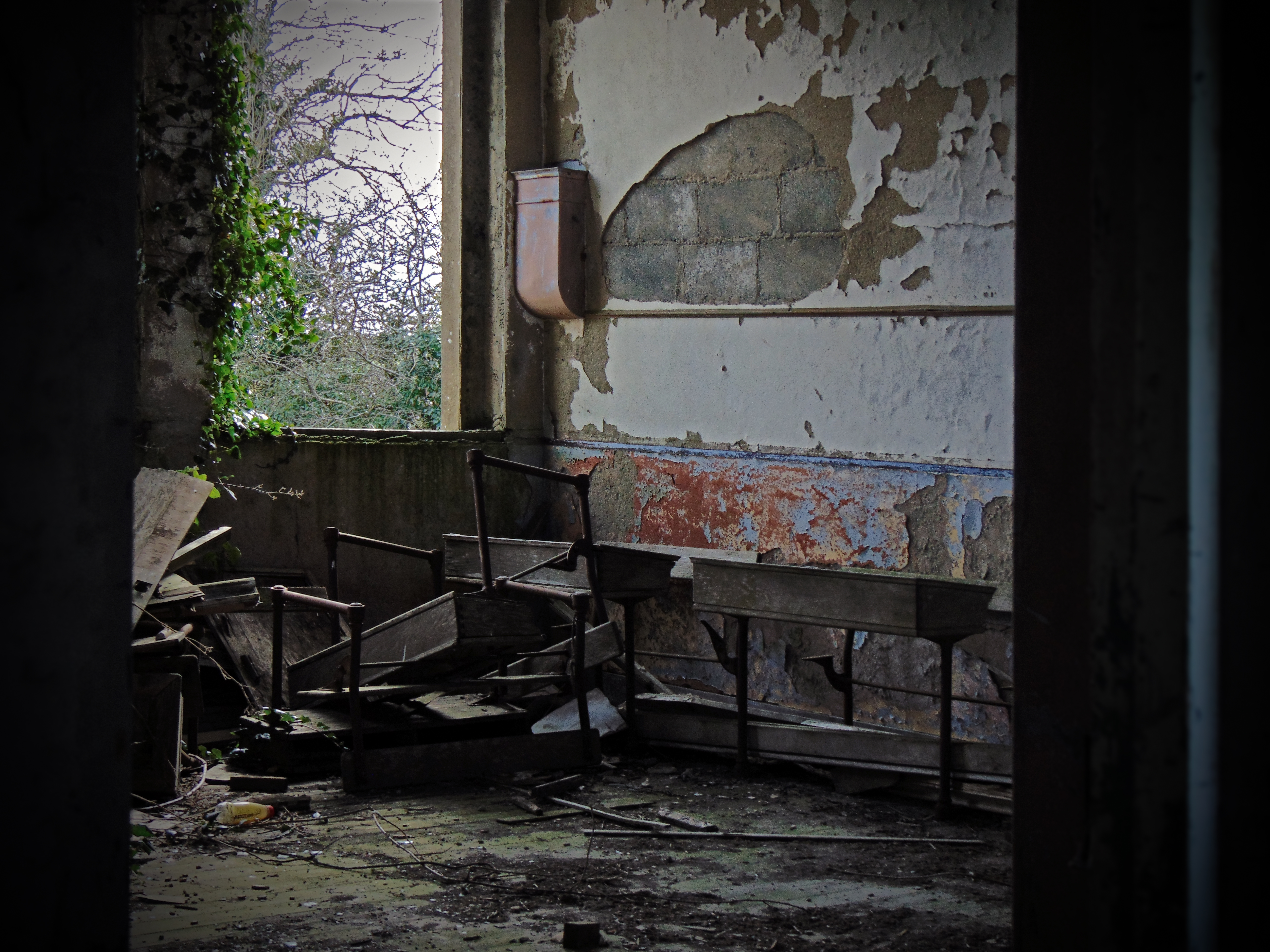
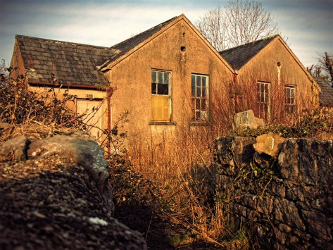
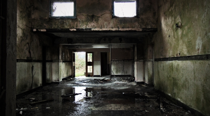
In the village of Latton in Co. Monaghan there has been a progression of four school houses since the first school building was marked on the First Edition Ordnance Survey in the 1840s. The national school featured in this blog post dates to 1941, and was replaced by the modern school building situated closer to the centre of the village.  Broadly similar in form and fabric to the school at Gortadooda in Co. Tipperary, this was a standard design by the Board of Works that was used throughout the country in the late 1930s and early 1940s.

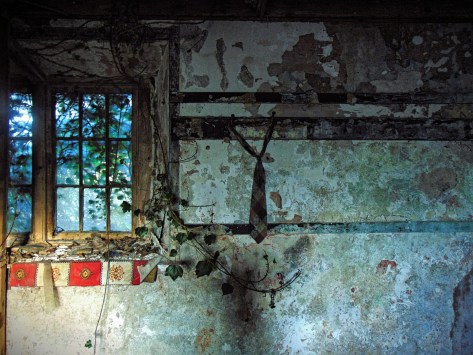
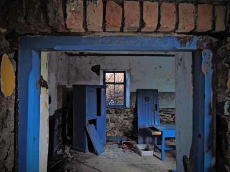
Now standing in open pasture, the structure is gradually giving way to the elements. To the front of the building there is an inscribed limestone date and name plaque reading ‘Scoil Mhuire Leacht Fhinn Scoil Náisiúnta 1941’. However, inside many of the fixtures and fittings remain, and each classroom retains much of the original furniture giving the environment a particularly spooky feeling.

Latton Co. Monaghan 1941 Hallway

Continue reading Latton National School, Latton townland, Co. Monaghan

Drumlish National School, Drumlish townland, Co. Longford

Drumlish National School, Drumlish townland, Co. Longford

(dated c.1930)

NGR: 215613,285673

Drumlish Co. Longford c.1930

The village of Drumlish is situated in North County Longford, close to the Cavan and Leitrim Borders, and near to the village of Ballinamuck. Just outside the centre of the village is Old School Road where a series of old school houses have stood over the past 180 years. The First Edition Ordnance Survey map from the mid-19th century shows a school house marked at the southern side of the modern R198 where the Cairn Hill View estate is now located. The Second Edition Ordnance Survey sheet from the turn of the 20th century shows that by this time, the school had moved to opposite the old Constabulary Barracks at the junction of Old School Road and the R198.  However, the school featured here post-dates both these buildings and is located to the east of the School Road Junction on the southern side of Old School Road. Here, hidden behind trees and brambles are the remains of a detached seven-bay single-storey former H-plan primary school, originally constructed c.1930 and extended c.1950.

Standing beside the building is a pebble-dashed water tower typical of 1950s school construction, while to the rear is a concrete playground shelter, which was cast in-situ. It is a particularly evocative abandoned schoolhouse, only going out of use in recent years. On entering the school through either of the cold, cast-in-situ side entrances, its functional 1950s architecture gives the interior a haunting feel, as encroaching nature gradually reclaims the building.

Drumlish Co. Longford c.1930

Continue reading Drumlish National School, Drumlish townland, Co. Longford

Bunnanaddan National School, Ballynaraw South townland, Co. Sligo

Bunnanaddan National School, Ballynaraw South townland, Co. Sligo

(dated 1883)

NGR: 160854, 311897

DSC04111[1]

County Sligo in the north-west of Ireland is undoubtedly rich in history, heritage, mythology and folklore. The dramatic and spectacular landscape rises from the wild Atlantic coast with expansive, sandy dunes and beaches, to the Tolkien-esque Dartry Mountains where every cave, cliff face and hill has its own unique story to tell. This environment lends itself easily to storytelling and the imagination, and it is easy to see why it has inspired and featured in a wealth of fantastical folklore throughout the millennia.

20160315_013605[1]

Continue reading Bunnanaddan National School, Ballynaraw South townland, Co. Sligo

Feohanagh National School, Feohanagh townland, Co. Limerick

Feohanagh National School, Feohanagh townland, Co. Limerick

(dated 1886)

NGR: 134051, 126163

Feohanagh National School, Co. Limerick

The rural landscape of many parts of Ireland is punctuated by small villages which, for various reasons, have fallen into decline in recent decades. In west Co. Limerick is one such village; ‘Feohanagh’ (the place of the thistles) located 5 miles south-east of the town of Newcastle West on the R522 road to Dromcollogher.

The First Edition 25 inch map (1898-1907) shows that at the turn of the 19thcentury this little hamlet included a smithy, a post office, a terraced street scene, the local church, and a two-roomed school house.  Today, no shops, post office or other services remain open here, though to the north side of the R522 are the remains of the disused two-roomed national school built in A.D. 1886.

Feohanagh National School, Co. Limerick

Continue reading Feohanagh National School, Feohanagh townland, Co. Limerick

Tullystown National School, Tullystown Cross, Co. Westmeath

Tullystown National School, Tullystown Cross, Co. Westmeath

(dated: c.1840)

NGR: 244969, 279596

20160217_224224.png

In 1837 the travelling antiquarian Samuel Lewis described the topography of Co. Westmeath as ‘diversified by hill and dale, highly picturesque in many parts, and deficient in none of the essentials of rural beauty, but timber’. Travelling north from the boglands of Co. Offaly into Co. Westmeath, there is certainly a notable change in the landscape – the brown watery flat-lands give way to green hillsides and winding roads which navigate the undulating farmland. Docile cattle peer over low stone walls, and traffic is largely agricultural.

20160217_224247.png

Continue reading Tullystown National School, Tullystown Cross, Co. Westmeath

Whiddy Island National School, Trawnahaha townland, Whiddy Island, Co. Cork

Whiddy Island National School, Trawnahaha townland, Whiddy Island, Co. Cork

(dated 1887)

NGR: 096974, 049791

Whiddy Island NS Co. Cork 1887 Doorway Looking in

Whiddy Island is a small, near-shore island located at the head of Bantry Bay in Co. Cork. Not far from the modern quayside and in the townland of Trawnahaha is a small late 19th-century one-roomed school house overlooking Bantry Bay below. Painted bright blue with a white lime-wash, in recent years the building had been used as a local museum though it has now fallen into a state of disrepair.

Whiddy Island NS Co. Cork 1887 Classroom Interior

Like so many offshore islands in Ireland, the permanent population has dwindled through the 20th century and can no longer support a local national school. John Chambers’ “Islands – Change in Population 1841 – 2011” clearly shows the island’s decline from a peak population of 729 in 1841:

Year Pop ±%
1841 729
1851 561 −23.0%
1901 259 −53.8%
1951 104 −59.8%
1996 34 −67.3%
2002 29 −14.7%
2006 22 −24.1%
2011 20 −9.1%

Whiddy Island NS Co. Cork 1887 Doorway

Continue reading Whiddy Island National School, Trawnahaha townland, Whiddy Island, Co. Cork