Tag Archives: rurex

Drumreilly National School, Kilnacreevey townland, Co. Leitrim 

Drumreilly National School, Kilnacreevy townland, Co. Leitrim

(dated: 1897)

NGR: 219888, 312629

Drumreilly National School Co. Leitrim 1897

Every now and then I find myself on the road when I chance upon some old empty school house by a roadside somewhere. I wouldn’t say that I’ve become obsessed with these abandoned buildings, but it recently occurred to me that in the past 12 months I’ve visited just over 100 tumbling down ruins of old schools, and that at the moment I feel compelled to stop and take a quick look around when I do accidentally stumble across one. While travelling from Ballymote to Armagh last month, I happened across a late 19th-century school house in the townland of Kilnacreevy in Co. Leitrim.

Drumreilly National School Co. Leitrim 1897

County Leitrim is Ireland’s least populous county, predominantly rural in character, with Carrick-on-Shannon being the only sizeable town of note. However, the countryside is stunning in an understated way, defined by rolling, boggy drumlins with small lakes interspersed between. The land is agriculturally poor, and the hollows between the drumlins tend to become water-logged and boggy. In 1837, the antiquarian Samuel Lewis described the region as ‘generally wet, sour, and moory’.

Drumreilly National School Co. Leitrim 1897

I feel Samuel Lewis was a little unfair with his description of the region. In the area around Garadice Lough on the Leitrim/Cavan border, meandering country lanes navigate the hillocks and lakes, and lead from one small village to the next. It is on the northern shore of Garadice Lough that you’ll find Kilnacreevy townland; a place that hasn’t changed much in the past 100 years.

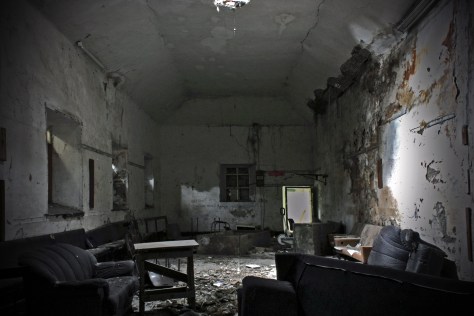
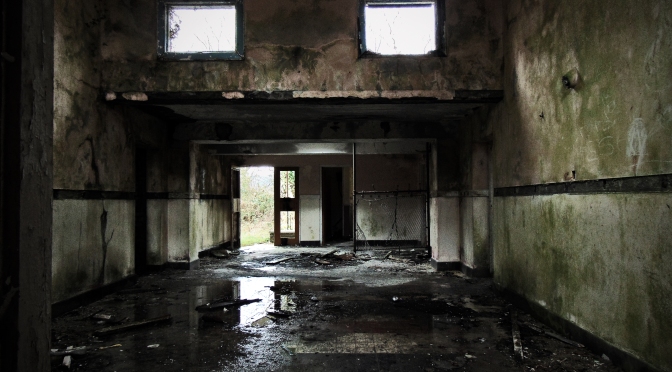
It was just a little over 100 years ago that a small one-roomed school house was built here overlooking the lakeshore. It is located on the northern side of the modern R199 road. The school building comprises a detached, single-storey, three-bay,one-roomed school house of rubble and brick construction, with a pitched slate roof. The date plaque indicates that it was constructed in 1897. It is near identical in form to the example from Sonnagh Old in Co. Galway, and in a similar state of decay.

Continue reading Drumreilly National School, Kilnacreevey townland, Co. Leitrim 

Dyzart National School, Dysart townland, Co. Louth

Dyzart National School, Dysart townland, Co. Louth
(Dated 1835)
NGR: 309710, 288382

dyzart-national-school-co-louth-1835
Dyzart National School, Co. Louth 1835

The parish of Dysart (occasionally spelled ‘Dyzart’) is located about 3 kms from Dunleer in Co. Louth, on the coast road from Drogheda to Dundalk. In 1837 the village was visited by the travelling antiquarian Samuel Lewis who reported 699 inhabitants living in the parish at the time. He noted that the land was of superior quality and well cultivated: about two-thirds in tillage, and about 50 acres of bog. In the village of Grange Bellew, there was a mill for grinding oatmeal, and another for dressing flax. Among the most notable buildings in the parish was the old castle of John Bellew in Barmeath (one of the lords of the English pale). At the time of Lewis’ visit it was the residence of Sir Patrick Bellew, and stood ‘in a richly wooded demesne, commanding extensive views of the surrounding countryside’.

In the village of Dysart, Lewis remarked on the handsome chapel there, the site for which was presented by Sir Patrick, who also contributed towards its erection. A quick look at the Ordnance Survey 6-inch sheet which dates to just a few years after Lewis’ visit, shows there were few buildings in Dysart during the 1830s-1840s, bar the aforementioned chapel, and a national school.

First Edition Ordnance Survey 6 inch sheet showing Dysart, Co. Louth.

Lewis recorded that the school of about 160 children was aided by Sir Patrick, who also contributed largely towards the erection of the school-house. Though now derelict, this building still stands today. Continue reading Dyzart National School, Dysart townland, Co. Louth

Munterneese National School, Munterneese townland, Co. Donegal

Munterneese National School, Munterneese townland, Co. Donegal
(Dated 1938)

NGR:183512, 375634

Located in the south of Co. Donegal, and on the northern shore of Donegal Bay, the village of Inver is sometimes referred to as the hidden jewel of the northwest. In recent years, the ‘Wild Atlantic Way’ coastal driving route has brought an increase in tourism to the area, with the parish being situated on the bay of Inver. Nonetheless it remains a quiet spot; rural in character with hilly and rough grazing land that is occasionally lashed by Atlantic winds and rain.

Although now quiet, the area was once home to an important whaling post during the 18th and 19th century, and a large whaling station and fleet was based in the Port of Inver, 2 km from the modern Inver Village.

Thomas and Andrew Nesbitt set up the whaling business in Donegal Bay in 1759. Thomas was the inventor of the gun-harpoon, which was witnessed by Arthur Young during his tour of Ireland 1776-1779, as he states: “From many experiments he brought the operation to such perfection that, for some years he never missed a whale, nor failed of holding her by the harpoon”.The ruins of the old whaling station still remain in the port but have eroded and deteriorated to rubble.

During the 19th century the area was busy enough to require a railway, and Inver railway station opened on 18 August 1893. However the final train passed through the station on 1 January 1960. It has been closed since.

Just a few kilometres east of Inver Village and situated to the south of the old railway tracks, are the townlands of Munterneese and Drumcoe. The townlands are sparsely populated today, though a quick glance at the historic mapping for the area shows that in the time since the publication of the First Edition Ordnance Survey 6 inch map series in the 1840s, there have been no less than four school houses constructed in this small area. Only two if these buildings remain today (both disused), and this blog post looks at the last of these to be constructed; a detached six-bay single-storey national school, dated 1938. Continue reading Munterneese National School, Munterneese townland, Co. Donegal

Lettermore National School, Lettermore townland, Co. Donegal

Lettermore National School, Lettermore townland, Co. Donegal
(Dated 1909)
NGR: 185124, 383735

Lettermore National School Co. Donegal (1909)

The island of Ireland is small but diverse. From the southwesternmost point at Mizen Head in Co. Cork, you need only travel about 550 km to reach the northerly tip of the country at Malin Head in Co. Donegal. But along that journey, you will witness a variety of landscapes, both physical and cultural – each different from the other in striking, or sometimes subtle ways. From productive mixed farmlands for both tillage and stock, to the mire of endless bog, the physical landscape has been shaped and manipulated, initially by geological process, and subsequently by the the people who have lived in it. Particularly in rural Ireland, the physical and cultural landscapes are entwined and form a narrative that is often not immediately clear, that requires an insight into, and interpretation of what shapes the lived experience of the world around you. In short, the landscape and what it contains tells the history of it’s inhabitants.

This blog post features the first abandoned school house from Co. Donegal (the northernmost county in Ireland) that I’ve visited, and it’s difficult to communicate the significance of the school without first placing this building in context.

Lettermore National School, Co. Donegal (1909)

The slogan ‘Up here it’s different’ has been used to promote tourism in, and attract tourists to the Donegal region in recent years. But what makes this area different? In terms of geography, Donegal is pretty similar to West Cork, Kerry and Connemara; a rugged western coastline shaped by the Caledonian Orogeny, and battered by the Atlantic Ocean, mountainous lands of blanket bog to the west, better, more productive lands to the east.

But Donegal different to these other places. Depending on your perspective, the circumstances of history have not done Donegal any favours other than to perhaps help preserve it’s striking landscape. The Partition of Ireland in the early 1920s had a massive direct impact on the county. Partition cut the county off, economically and administratively, from Derry, which had acted for centuries as it’s main port, transport hub and financial centre. But even before this, Donegal was one of the worst affected parts of Ulster during the Great Famine of the late 1840s. Vast swathes of the county were devastated by this catastrophe, many areas becoming permanently depopulated. Vast numbers of people emigrated at this time. Particularly in West Donegal, there was a spiral of decline from the 1900s onward, and what was once seasonal migration from the islands and highlands was replaced by more permanent migration to cities in Britain such as Glasgow.

Lettermore National School, Co. Donegal (1909)

The abandoned school house at Lettermore symbolises the recent history of the region, and the story of migration. Opened in 1909 to meet the educational needs of the local community, the school had a relatively short life. Continue reading Lettermore National School, Lettermore townland, Co. Donegal

Drumlish National School, Drumlish townland, Co. Longford

Drumlish National School, Drumlish townland, Co. Longford

(dated c.1930)

NGR: 215613,285673

Drumlish Co. Longford c.1930

The village of Drumlish is situated in North County Longford, close to the Cavan and Leitrim Borders, and near to the village of Ballinamuck. Just outside the centre of the village is Old School Road where a series of old school houses have stood over the past 180 years. The First Edition Ordnance Survey map from the mid-19th century shows a school house marked at the southern side of the modern R198 where the Cairn Hill View estate is now located. The Second Edition Ordnance Survey sheet from the turn of the 20th century shows that by this time, the school had moved to opposite the old Constabulary Barracks at the junction of Old School Road and the R198.  However, the school featured here post-dates both these buildings and is located to the east of the School Road Junction on the southern side of Old School Road. Here, hidden behind trees and brambles are the remains of a detached seven-bay single-storey former H-plan primary school, originally constructed c.1930 and extended c.1950.

Standing beside the building is a pebble-dashed water tower typical of 1950s school construction, while to the rear is a concrete playground shelter, which was cast in-situ. It is a particularly evocative abandoned schoolhouse, only going out of use in recent years. On entering the school through either of the cold, cast-in-situ side entrances, its functional 1950s architecture gives the interior a haunting feel, as encroaching nature gradually reclaims the building.

Drumlish Co. Longford c.1930

Continue reading Drumlish National School, Drumlish townland, Co. Longford