
Gleann Cotáin (Glencuttane) National School, Glancuttaun Upper townland, Co. Kerry
(dated: 1887)
NGR: 77839, 089223
The townland of Glancuttaun Upper is situated in the parish of Kilorglin on the northeastern side of the Iveragh peninsula in Co.Kerry. The landscape here comprises areas of low-lying farmland shadowed by low mountainous terrain with it’s rough grazing lands. A quick look at the First Edition 25 inch Ordnance Survey sheet shows field patterns that demonstrate how the lands and landscape here were exploited in the past; by the roadside and in the low-lying, more fertile areas we find tightly packed, small enclosed fields close to the clachan style settlements that are so characteristic of the rural Irish landscape. The mountain sides remain unenclosed.

These field patterns reflect a system of farming and animal husbandry in Ireland that stretches back millenia. Traditionally, cattle farming was the mainstay of Gaelic life in Ireland, and stock was effectively currency. Early law tracts dedicate significant detail to the care of cattle, and rights and obligations of cattle owners. During winter, stock was commonly kept enclosed about the homestead, while in the summer months, cattle were driven to rough summer grazing in the uplands. This ancient settlement pattern is still visible today in the modern landscape around Glancuttaun.
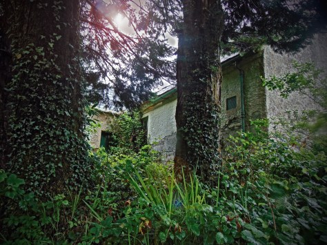
It is on the low-lying and more populated lands of Glancuttaun Upper that Glencuttane National School was constructed in the late 19th century. Dating to 1887, it is merely a ruinous, roofless frame of a building today. The thinly spread soil around the school is often water-logged, and on an overcast day that I visited, it seemed a particularly dour place. Having said this, I passed here again on a brighter afternoon, and the fair weather helped to lighten the sad look of the old grey building.

The building itself comprises a detached five-bay, single-storey national school, built c.1887. To the front there is a single-bay single-storey gabled projecting entrance bay to the centre. The school is enclosed by a rubble boundary wall with stone-on-edge coping, and includes wrought-iron gates that are entangled with the overgrown grass.

The original slate roof of the school has been removed exposing the interior of the building to elements. The glazing is gone, and the weather beaten exterior looks a sorry sight by the roadside. Inside there are two classrooms with fireplaces located centrally in the building. The suspended floor has collapsed, and I had to negotiate the rubble, being careful not to impale myself on the debris.

Some cute details remain in the building such as the wrought-iron coat hooks in the entrance hall, but the building is largely a ruin that is difficult to negotiate. Nonetheless, the building once served an important social role in the local community.

However, Glencuttane school house is absent from the National Inventory of Architectural Heritage, despite it’s social and architectural value. This is a phenomenon that I have highlighted before, where identical school houses in different counties may or may not be included in the National Inventory, with no clear reasoning behind their absence or inclusion. Although the NIAH is a national inventory, it is not homogeneous from county to county. Is this something that can be addressed?